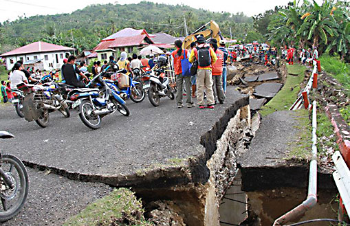
Earthquake hits Negros Oriental, Five years ago
For people who live on or near an active fault line – such as the San Andreas Fault in California, the Median Tectonic Line in Japan, or the Sunda Megathrust of southeast Asia – earthquakes are a regular part of life. Oftentimes, they can take the form of minor tremors that come and go without causing much damage.
But at other times, they are cataclysmic, causing widespread destruction and death tolls in the thousands or more. But what exactly is an earthquake? What geological forces lead to this destructive force? Where do they typically happen, and how many different types are there? And most importantly, how can we be better prepared for them?
Statement of PHILVOCS-DOST
"
REMINISCENCE OF THE 2012 Ms6.9 NEGROS ORIENTAL QUAKE
The Philippine Institute of Volcanology and Seismology – Department of Science and Technology (PHIVOLCS-DOST) commemorates the 2012 Negros Oriental Earthquake on its 5th year.
A magnitude 6.9 earthquake shook the islands of Negros, Cebu, and nearby islands of Western Visayas region at 11:49 A.M. on February 6, 2012. The earthquake was generated by a thrust fault movement with the epicenter located in Tayasan, Negros Oriental. An Intensity VIII (very destructive) was felt in Tayasan, Vallehermoso, Jimalalud, La Libertad, and Guihulngan, Negros Oriental.
The estimated total cost of damage to infrastructure was Php 383,059,000.00.00. A total of 51 dead and 112 injured while 62 were missing from the landslide in Solongon, La Libertad and Planas, Guihulngan (NDRRMC SitRep No. 22, 20 Feb 2012)
Tsunami waves as high as five (5) meters struck Barangays Martilo, Pisong, and Magtalisay in La Libertad, Negros Oriental. Coastal areas of Negros Oriental from San Jose to Vallehermoso, and Cebu from Badian to Barili were also affected by the tsunami.
Evidence of liquefaction was reported in Ayungon, La Libertad, Guihulngan, Jimalalud, and Tayasan. The most extreme lateral spread combined with ground undulation and subsidence occurred along the approach of Tuway Bridge affecting approximately 100 meter stretch of the road. Many bridges and some structures suffered from loss of bearing capacity. The Pangaloan Bridge and Martilo Bridge collapsed and were rendered temporarily impassable for days.
Negros and Cebu Islands are located in a seismically active area in the Philippines. Earthquake generators such as Negros and Sulu Trench, segments of the Philippine Fault in Masbate and Leyte Islands and active faults in Negros and Cebu Islands may generate earthquakes that could affect the area. Evaluation of structural safety of buildings, public facilities, and houses are recommended as well as continuous intensive community-wide earthquake and tsunami information and education campaigns and drills.
On the 5th year of the 2012 Ms 6.9 Negros Oriental Earthquake, PHIVOLCS encourages everyone to look back and remember not only the tragedy, but also the lessons we learned. Awareness and preparedness will increase our chances against natural hazards and disasters. Through the continuous development and application of technologies for monitoring, and Information, Education, and Communication (IEC) campaign of PHIVOLCS, let us keep our communities safe from and resilient to volcanic eruptions, earthquakes, tsunamis and other related hazards."
For more information contact:
Dr. Renato U. Solidum, Jr.
Director
Philippine Institute of Volcanology and Seismology
PHIVOLCS Bldg., C.P. Garcia Ave., UP Diliman Campus, Quezon City
Tel. No: (02) 926 2611 or (02) 426-1468 to 79
www.phivolcs.dost.gov.ph


